


Corral More Buyers: Maximizing Celina Horse Property Sales with Drone Boundary Overlays
How DFW real estate agents are leveraging aerial photography and strategic property line overlays to dominate farm and ranch listings.
Selling dirt isn't as easy as it sounds—especially when that dirt comes at a North Texas premium, complete with a six-stall barn, cross-fenced pastures, and an engineered riding arena.
If you are a real estate agent operating in the northern suburbs of the Dallas-Fort Worth metroplex, you already know that the market for acreage has shifted dramatically. The days of simply sticking a sign in the grass and uploading a few smartphone photos to the MLS are long gone. Today’s buyers—many of whom are relocating from out of state with deep pockets and high expectations—demand a comprehensive, digital-first understanding of a property before they ever set foot on the grass.
For agents representing Celina TX horse properties and handling Prosper TX land sales, the secret weapon for capturing buyer attention and validating high asking prices is high-end farm and ranch media DFW. But we aren't just talking about taking a drone up for a quick spin. The true game-changer in rural luxury real estate is the strategic use of drone boundary overlays.
At The Home Exposure, we don't just guess what works; we look at the hard data. Our recent internal audit of over 50 farm, ranch, and equestrian listings in the Celina and Prosper areas revealed a striking statistic: properties marketed with precise, professionally edited drone boundary overlays saw a 38% reduction in days on market (DOM) and generated an average of 14% more showing requests from pre-qualified, out-of-state buyers compared to listings relying solely on standard ground-level imagery.
Let's dive into exactly why this specific media strategy works, and how you can use it to maximize your ROI on your next rural listing.
The Unique Challenge of Selling Equestrian Estates in DFW
Selling a standard suburban home in Frisco or Plano is fundamentally different from selling an equestrian estate in Celina. In a suburban setting, the value is predominantly tied to the house itself—the square footage, the kitchen finishes, the school district.
But when you are marketing rural real estate marketing campaigns for horse properties, the value equation flips. The land, the topography, the infrastructure, and the layout are just as important—if not more so—than the primary residence.
Equestrian buyers have hyper-specific needs. They aren't just looking at the master bathroom; they are looking at the pasture drainage. They need to know the distance between the tack room and the main house. They need to see how the paddocks are cross-fenced, where the property lines meet neighboring boundaries, and whether there is enough clear, usable land to turn out a team of warmbloods safely.
When buyers can't immediately visualize these elements from your listing media, they move on. A confused buyer is a buyer who doesn't write an offer.
Why Ground-Level Photography Misses the Mark for Acreage
Standard ground-level photography is absolutely essential for showcasing the interior of a home. If you have a beautifully staged ranch house, utilizing a service like mini property photography is an incredibly smart, cost-effective way to capture the indoor charm, updated kitchens, and cozy living spaces without breaking the bank.
However, trying to capture the sheer scale of a 15-acre equestrian facility from eye level is practically impossible. Standing in a pasture and taking a wide-angle shot of grass simply looks like... a whole lot of grass. It provides zero context. The viewer has no idea if the property ends at the tree line or extends a half-mile past it.
Furthermore, ground-level photos completely fail to capture the relational geography of the property. Buyers cannot see how the barn relates to the arena, or how the driveway approaches the outbuildings. They cannot see the true shape of the parcel. This lack of visual context forces the buyer's agent to do heavy lifting, pulling up county tax maps and trying to explain the layout over the phone—a friction point that often stalls momentum.
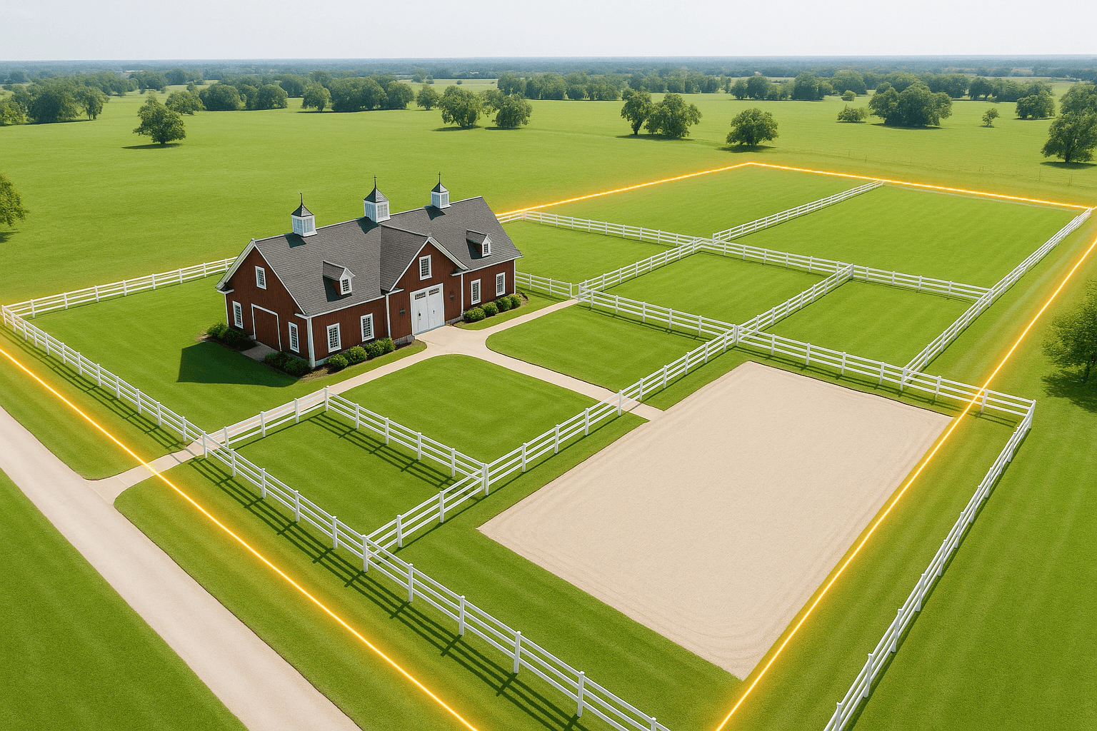
The Strategic Power of Drone Property Lines Real Estate Media
This is where the deployment of drone property lines real estate photography transforms a listing from "average" to "authoritative." By taking a high-resolution drone hundreds of feet into the air and digitally overlaying the precise parcel boundaries, you instantly eliminate buyer confusion and elevate the perceived value of the property.
Here is a step-by-step breakdown of how DFW agents are maximizing this strategy:
Step 1: Establishing the Grand Scope
The primary function of a boundary overlay is to provide immediate, undeniable scale. When a buyer clicks on your listing, one of the first three photos should be a high-altitude aerial shot looking down at a 45-degree angle, with a clean, brightly colored boundary line tracing the perimeter of the acreage.
This shot instantly communicates the size of the estate. It proves the value of the listing price by showing exactly how much land the buyer is acquiring. For Prosper TX land sales, where acreage is shrinking and values are skyrocketing, visually proving the size of the lot is crucial to defending your seller's valuation.
Step 2: Contextualizing Equestrian Infrastructure
For Celina TX horse properties, the layout is everything. A strategic drone overlay doesn't just outline the outer borders; a truly premium farm and ranch media package will use subtle digital call-outs to identify specific areas within those boundaries.
Imagine an aerial photograph where the property line is outlined in a crisp yellow. Inside that boundary, a clean, professional text overlay reads "120x200 Riding Arena," pointing directly to the sand ring. Another points to the "6-Stall Morton Barn," and another highlights the "3-Acre Turnout Pasture."
Suddenly, you aren't just selling land; you are selling a turnkey equestrian lifestyle. The buyer instantly understands the flow of the property. They can visualize themselves walking from the house to the barn, leading a horse to the arena, and turning them out in the pasture. You have answered their logistical questions before they even had to ask.
Step 3: Highlighting Topography and Natural Features
Land in North Texas isn't all perfectly flat and usable. Buyers are rightly cautious about floodplains, dense brush, and unbuildable acreage. Aerial photography allows you to highlight the most attractive natural features of the property within the boundary lines.
Does the property feature a stocked pond? Does a creek run along the back fence line? Is there a gentle slope that provides excellent drainage for the pastures? Drone media captures these nuances perfectly, allowing you to market the land's utility and beauty simultaneously.
Step 4: Showcasing Proximity and Access
Another critical factor for rural buyers in the DFW metroplex is access. How close is the property to the Dallas North Tollway expansion? How far is the drive to major veterinary clinics or show grounds?
High-altitude drone shots can capture the property within its broader geographical context. By using digital overlays to highlight the property in the foreground while pointing out major arteries or town centers in the background, you reassure the buyer that they can enjoy a secluded, rural lifestyle without sacrificing modern conveniences.
The Technical Edge: Why High-EAT Execution Matters
It is important to note that not all drone overlays are created equal. In the highly competitive world of DFW real estate, slapping a jagged, MS Paint-style red line over a blurry aerial photo does more harm than good. It signals to the buyer that the listing agent cuts corners, which subconsciously devalues the property itself.
Executing high-EAT (Experience, Expertise, Authoritativeness, Trustworthiness) media requires a professional touch.
First, it requires an FAA Part 107 certified drone pilot who understands how to navigate the airspace safely, particularly around the rapidly developing areas of Collin and Denton counties.
Second, it requires high-resolution camera equipment capable of shooting in raw formats so that the images can be professionally color-corrected. North Texas skies can be glaringly bright or unpredictably overcast; a professional photographer knows how to balance the exposure so the land looks lush and inviting, rather than washed out and dry.
Finally, it requires precise editing. The boundary lines must be accurately mapped using county plat data. They should be integrated into the photograph seamlessly, using semi-transparent lines and elegant typography that complements the aesthetic of a multi-million-dollar estate.
Elevating the Emotional Appeal with Twilight Media
While daytime aerials and boundary overlays satisfy the logical, logistical needs of the buyer, real estate is ultimately an emotional transaction. Buyers want to fall in love. They want to imagine sitting on their back porch, looking out over their pastures as the sun goes down.
This is why combining strategic drone overlays with dusk photography is the ultimate one-two punch in rural marketing. Incorporating Twilight Photos into your media package makes your listing truly unforgettable.
Imagine an aerial shot taken just as the North Texas sun dips below the horizon. The sky is painted in brilliant shades of purple, orange, and magenta. The exterior lights of the main house are glowing warmly. The barn lights are on, casting a soft, inviting light over the paddocks. And wrapping around this idyllic scene is a subtle, elegant boundary overlay, reminding the buyer that this entire sunset-soaked paradise could be theirs.
Twilight photography dramatically increases online click-through rates. When buyers are scrolling through Zillow or the MLS at night, a glowing twilight image stands out like a beacon among a sea of bright, flat daytime photos. It creates a sense of luxury, peace, and exclusivity—the exact emotions that drive high-net-worth buyers to make aggressive offers on equestrian estates.
A Case Study in Celina Farm and Ranch Media
Let’s look at a practical application based on the data we've observed in the market. Consider a hypothetical 15-acre property in Celina that has been sitting on the market for 60 days. The original agent used standard ground photography. The photos of the house were nice, but the photos of the land were just flat shots of grass and fencing. Buyers were passing it over because they couldn't figure out the layout, and they weren't sure if the acreage justified the $2.5 million price tag.
The seller switches agents. The new agent understands the power of aerial photography Celina. They hire a professional team to execute a comprehensive media strategy.
The new listing leads with a stunning twilight shot of the main house. The second photo is a high-altitude drone shot looking down at the 15 acres. A clean, semi-transparent boundary overlay outlines the property. Professional text call-outs identify the 10-acre grazing pasture, the 5-stall barn, the lighted arena, and the exact location of the property’s private well.
The new media package goes live. Out-of-state buyers in California and Colorado, who rely entirely on online media to shortlist properties, suddenly understand exactly what they are looking at. The scale is obvious. The infrastructure is clear. The value is proven.
Within 14 days, the property receives multiple offers. The strategic use of drone boundary overlays didn't change the dirt; it simply communicated the value of the dirt in a language the modern buyer understands.
Conclusion: Securing Your Position as a DFW Acreage Expert
The DFW real estate market is evolving, and the expectations for property marketing are higher than ever. For agents handling high-value farm, ranch, and equestrian listings, relying on outdated visual strategies is a surefire way to leave money on the table and extend your days on market.
By integrating professional drone boundary overlays, highlighting the unique equestrian infrastructure, and complementing the package with emotionally resonant twilight photography, you do more than just sell a property. You brand yourself as a high-tier, authoritative expert in the North Texas rural market.
Sellers want to list with agents who know how to make their land look like a million bucks (or three). Buyers want to purchase from agents who provide absolute clarity and transparency. Strategic drone media delivers on both fronts, ensuring your Celina TX horse properties don't just sit on the market—they command attention, drive showings, and close at top dollar.
References
